MBXMapKit 0.8.0
| TestsTested | ✗ |
| LangLanguage | Obj-CObjective C |
| License | BSD |
| ReleasedLast Release | Aug 2015 |
Maintained by Unclaimed.
MBXMapKit 0.8.0
- By
- Mapbox
- Mapbox
MBXMapKit is deprecated in favor of the Mapbox iOS SDK 2.0.0 and above. The future of Mapbox maps is vector rendering, and Apple shows no signs of allowing custom vector rendering in MapKit, so we recommend that you use the OpenGL-based Mapbox iOS SDK 2.0.0 instead.
MBXMapKit extends Apple's MapKit to integrate with maps hosted on Mapbox, combining the performance of native maps with convenience and integration similar to Mapbox.js. With MBXMapKit, your app is responsible for providing and managing its own MKMapView instance, while MBXMapKit provides tile overlays, annotations, and an offline map downloader so you can easily display maps from Mapbox both online and offline.

Features
The main features which MBXMapKit adds to MapKit are:
Online Maps: You can initialize a raster tile layer using a Mapbox map ID, and MBXMapKit will handle the details of generating tile URLs and asynchronously loading metadata and markers. With MBXMapKit's delegate callbacks for asynchronously loaded resources, you have the option to immediately start rendering your map, then as the necessary data becomes available, to adjust the visible region and add markers to match how the map is configured in the Mapbox online editor.
Offline Maps: MBXMapKit includes an offline map downloader to manage the download of all resources (tiles, JSON metadata, and marker icons) necessary to display requested map regions while offline. The offline map downloader provides download progress updates, an internal mechanism for persistant storage of multiple offline map regions, the ability to remove specific offline map regions from disk, and the ability to include offline map data in iCloud backups (the default however is to exclude offline map data from backups).
Mapbox Markers: If you've configured markers for your map using the Mapbox online editor, MBXMapKit makes it easy to add them to your
MKMapViewasMKShapeannotations. You'll need to include some simple boilerplate code in your view controller's-[MKMapViewDelegate mapView:viewForAnnotation:]in order to connect annotations with regularMKAnnotationViewinstances (see the iOS sample app).Performance Caching: MBXMapKit uses
NSURLSessionandNSURLCachefor performance caching of the tiles, JSON metadata, and icons required for loading maps. In contrast to the Mapbox iOS SDK and earlier versions of MBXMapKit, this is a traditional cache which is not designed to be used for long term persistence of map data while offline. That capability is provided by a separate mechanism.
Concepts
The fundamental concept to understand about MBXMapKit is that it is designed to add features to Apple's MapKit rather than to replace or encapsulate MapKit.
You are responsible for managing your own MKMapView, and MBXMapKit will stay out of your way. MBXMapKit provides MKTileOverlay and MKShape subclasses which you can add to your MKMapView in combination with overlays and annotations from other sources. To see how MBXMapKit makes that process fairly painless, and for several examples of configuring MKMapView for different visual goals, please take a look at the view controller in the iOS sample app.
With MBXMapKit, there is a clear distinction between performance caching and persistent offline storage. If iOS decides it needs to free up disk space by deleting items in app cache directories, offline map data won't be affected.
Requirements
- iOS 7.0+
- Xcode 5+
- Automatic Reference Counting (ARC)
Releases
Generally speaking, MBXMapKit follows the conventions described by GitHub's Release Your Software post.
Typically we develop new features as branches, and then merge them into the master as we are preparing for a release. When an official release is ready, we create a tag with the version number. You can view the list of releases at https://github.com/mapbox/mbxmapkit/releases.
Installation
To include MBXMapKit in your app you will need to:
Copy all the
.mand.hfiles from theMBXMapKitfolder into your project.Make sure that the
.mfiles are included in your build target (select the project, select build target, select Build Phases tab, expand the Compile Sources heading, and make sure all the.mfiles are listed).Make sure you have the map capability turned on for your build target (select project, select build target, select Capabilities tab, flip the switch to
ONfor Maps).Make sure that your build target is linked with
libsqlite3.dylib(select project, select build target, select Build Phases tab, expand Link Binary With Libraries, and check the list). When you turn on the map capability, the MapKit framework should be added automatically, but you will probably need to addlibsqlite3.dylibunless you are already using SQLite for something else.Study the view controller in the iOS sample app. It's meant to be liberally copied and pasted. In particular, take a look at
-viewDidLoad,-resetMapViewAndRasterOverlayDefaults,-actionSheet:clickedButtonAtIndex:, theMBXOfflineMapDownloaderDelegatecallbacks,-mapView:rendererForOverlay:,-mapView:viewForAnnotation:, and theMBXRasterTileOverlayDelegatecallbacks if you have any questions about how things work.Provide some prominent means to display any applicable map data copyright attribution messages. For maps which include OpenStreetMap data, that means you need something which links to the OSM copyright page (see sample app for an example). More details are available at https://www.mapbox.com/help/attribution/ and http://www.openstreetmap.org/copyright.
Support
If you have questions about how to use MBXMapKit, or are encountering problems, here are our suggestions for how to proceed:
Read all of this README, review the documentation in the MBXMapKit header files, and check if what you're trying to do is similar to anything in the sample app.
Search the web for your problem or error message. This can be very helpful for distinguishing MBXMapKit specific problems from more general issues with MKMapKit, and it may also guide you to relevant GitHub issues or StackOverflow questions. In many cases, documentation and blog posts about using MKMapKit will also be applicable to MBXMapKit.
Familiarize yourself with the documentation and developer resources on Mapbox.com (Help, Guides, and Developers).
Take a look at the MBXMapKit issues on GitHub.
Take a look at Mapbox questions on StackOverflow.
If none of that helps, you can file an issue on GitHub, ask a question on StackOverflow, or contact Mapbox support.
Sample App
The sample app is meant to demonstrate the full capabilities of MBXMapKit and to show examples of different ways to configure an MKMapView. We've also found it to be useful for testing for responsiveness and visual glitching during work on the API implementation.
A quick tour:
Start the sample app.
Tap the info button in the bottom right corner to bring up an action sheet with several map configurations and an option to view the attribution dialog.
Try the different map configurations, then take a look at
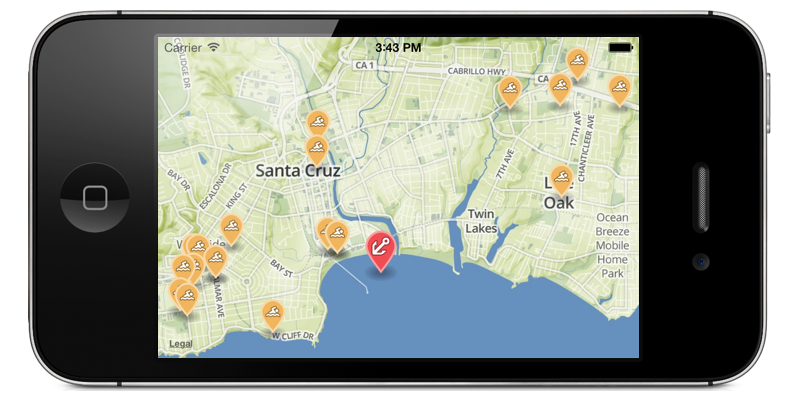
-resetMapViewAndRasterOverlayDefaultsand-actionSheet:clickedButtonAtIndex:fromMBXViewController.mto understand what's going on. The basic idea is that when the map configuration gets switched, theMKMapViewis reverted to a known state by removing overlays and markers, then new overlays and markers are added for the new configuration.Note that World baselayer, no Apple map includes several orange swim markers in Santa Cruz, CA. The callout text comes from the map's
features.jsonfile, which is loaded from the Mapbox API, and the icons are also loaded from the Mapbox API after the necessary specifications are parsed out offeatures.json. The map center coordinate and zoom scale come from the map's metadata JSON (i.e.,your-map-id.json). The markers, centering, and zoom get applied to the map by way of the view controller'sMBXRasterTileOverlayDelegatecallback implementations.Note how Offline map downloader provides a view in the center of the screen with controls to begin, cancel, suspend, and resume the downloading of an offline map region. To select the region to be downloaded, just adjust the visible map region before hitting the begin button. When a download is active, you should see the progress indicator at the bottom of the screen. The progress indicator will remain on screen if you switch to other maps. If you kill the app before the download is complete, it should resume when you re-launch the app.
Note how the Offline map viewer will show the most recent offline map region which was completely downloaded at the time you switched to Offline map viewer. Note how the offline map includes markers, initial centering, and initial zoom, even when airplane mode is enabled. There is also a button with a confirmation dialog for deleting all the stored maps. While the sample app only shows the most recently downloaded offline map, the API is designed so that you can enumerate all the available offline maps and use whichever ones you want.
Platforms
MBXMapKit is officially supported for iOS 7.0 and later. While iOS is the main priority, we also hope to keep things OS X friendly (10.9 and later since MapKit is required). That means you may notice instances of #if TARGET_OS_IPHONE around UIImage/NSImage and such, and it's possible the OS X side of some of those things may be broken.
If you encounter an OS X related problem and want to file an issue or pull request on GitHub, it would be welcome and appreciated. In particular, if you're working on an OS X app which needs something more than Mapbox.js in a WebView (offline maps?) we'd like to hear about it.
See Also
Check out the overview guide for summary details.
You might also be interested in the Mapbox iOS SDK, which is a ground-up rewrite meant as a replacement for Apple's MapKit, not an extension of it. If you've always wished MapKit was open source for complete customizability, the Mapbox iOS SDK is for you.